notes.husk.org/likes
images.
tagged satellite imagery.
page 2 of 5 with 107 images.
aerial view
farmland
agricultural fields
pattern
bird's eye view
satellite imagery
landscape
agriculture
geometric
texture
Daily Overview
aerial view
satellite imagery
desert landscape
top-down perspective
paved tracks
geometric patterns
arid environment
infrastructure
minimalist composition
desert terrain
Daily Overview
aerial view
satellite imagery
mountain peak
volcano
snow-capped
glaciers
landscape
nature
topography
alpine
Daily Overview
2 images
aerial view
satellite imagery
evaporation ponds
salt pans
mineral extraction
arid landscape
desert landscape
aerial photography
topography
abstract pattern
Dan W, Software Developer
aerial view
satellite imagery
desert landscape
geometric pattern
top-down perspective
man-made structures
symmetry
arid terrain
architectural layout
drone photography
Daily Overview
refugee camp
satellite imagery
time-lapse
urban expansion
humanitarian aid
aerial view
geospatial analysis
middle east
displacement
population growth
STML
2 images
aerial view
satellite imagery
heatmap
parking lot
grayscale
data visualization
urban planning
geospatial
mapping
density map
Dan W, Software Developer
3 images
aerial photography
agriculture
farmland
irrigation
crop rows
geometric patterns
satellite imagery
land use
textures
farming patterns
Notational
aerial view
cityscape
colorful overlay
abstract art
satellite imagery
urban landscape
digital art
multicolored
geometric patterns
urban textures
Dan W, Software Developer
8 images
aerial view
satellite imagery
industrial landscape
agricultural fields
shipping containers
evaporation ponds
salt pans
geometric patterns
earth observation
landscape photography
Notational
aerial photography
satellite imagery
evaporation ponds
salt flats
desert landscape
mineral extraction
abstract pattern
top-down view
lithium mining
earth observation
Dan W, Software Developer
aerial view
satellite imagery
island
urban landscape
cityscape
ocean
coastal
seascape
dense urban area
blue water
Daily Overview
aerial view
architecture
symmetry
geometric pattern
blue roof
building complex
top-down view
drone photography
abstract pattern
satellite imagery
Daily Overview
aerial view
satellite imagery
archipelago
coastline
islands
ocean
coastal landscape
blue water
bay
topography
Dan W, Software Developer
aerial view
airport
runway
urban landscape
satellite imagery
cityscape
top-down view
aviation
infrastructure
residential area
Daily Overview
satellite imagery
aerial view
evaporation ponds
lithium mining
salt evaporation
industrial landscape
mineral extraction
brine ponds
top-down view
geometric patterns
Daily Overview
aerial view
satellite imagery
cityscape
urban landscape
map
architecture
urban planning
infrastructure
grid pattern
digital data
deathbeard
arctic
satellite imagery
map
geography
north pole
earth science
climate
cartography
weather
atmosphere
Dan W, Software Developer
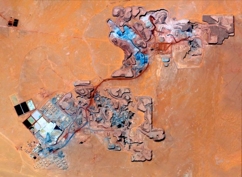
satellite imagery
aerial view
open-pit mine
mining industry
desert landscape
earthwork
resource extraction
arid terrain
excavation site
industrial landscape
Daily Overview
remote sensing
nasa
geography
geospatial
satellite imagery
research
SCIIENCE
aerial view
satellite imagery
suburban landscape
residential area
housing development
top-down view
urban planning
neighborhood
infrastructure
street pattern
Daily Overview
aerial view
industrial zone
port
shipping terminal
logistics center
warehouse
infrastructure
satellite imagery
cargo
river
Daily Overview
satellite imagery
breakwater
sediment plumes
ocean currents
aerial view
coastline
marine environment
harbor
coastal morphology
turquoise water
Dan W, Software Developer
aerial view
satellite imagery
bridge
aquaculture
fish farm
ocean
coastline
marine
infrastructure
top-down view
Daily Overview